
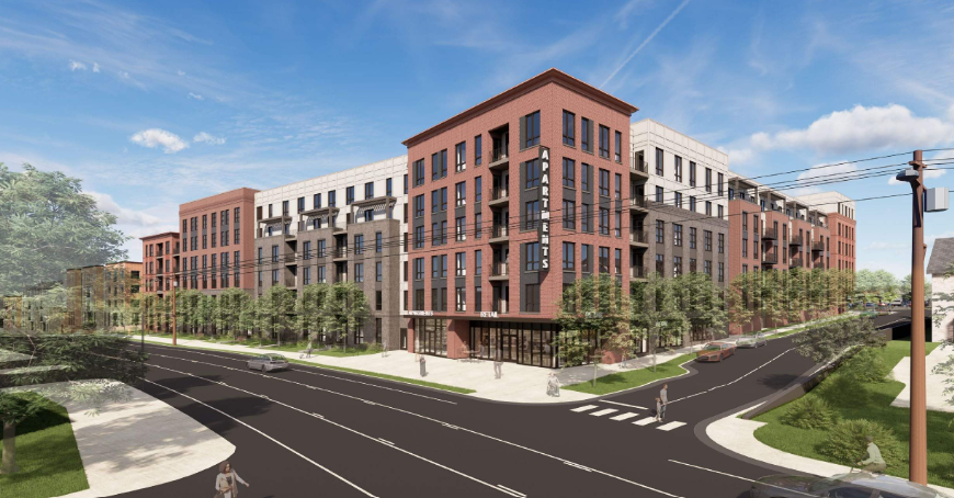
Courthouse Plaza
Under ReviewPrivate Development · 10300 Willard Way and 3922 Blenheim Boulevard, Fairfax, VA 22030 · topic history · city record ↗ · on the map
630 units · 74,059 sq ft retail · 6 stories · 10.34 acres
In plain terms: the project would add roughly 1,077 residents and about $2.5M a year in new property tax, but serving those residents costs money too. Counting the city services that actually grow with new residents, that nets out to a net gain of about $496k a year, anywhere between a net cost of about $2.6M a year and a net gain of about $3.7M a year across the assumption ranges. Fixed citywide costs are not charged to new residents; school costs follow the project's own student estimate.
Where the effects land
The economic map shows total captured spending by business location and named reporting clusters. The walk map uses a tighter extent around walk-arriving capture and the street segments assigned new resident walk trips; the bike map (when present) shows bike-arriving capture across the city — bikes reach farther, so it spreads wider and thinner. Dollar heatmaps are clipped to CR (Commercial Retail) zoning, and each map is scaled to its own data, so colors are not comparable across maps.
Summary
Courthouse Plaza is a proposed mixed-use redevelopment of a 10.34-acre single-story retail shopping center in the City of Fairfax, Virginia. The applicant proposes to replace approximately 91,850 square feet of existing retail and surface parking with 630 multifamily residential units (including approximately 38 affordable units) and 74,059 square feet of ground-floor retail across two six-story buildings. This analysis projects a net increase in real estate tax revenue of $2,386,507–$3,216,533 per year and, under the marginal cost framing, a net annual fiscal impact ranging from approximately −$2,565,438 to +$3,677,635 — a range wide enough that the sign of the net impact is not resolved. The project is projected to add 850–1,344 new residents and generate new annual household spending across grocery, restaurant, comparison retail, entertainment, and other categories. The three assumptions to which the resident-population estimate is most sensitive are: (1) the average household size assumed for new multifamily units (central value 1.8 persons, range 1.5–2.2); (2) the stabilized occupancy rate (central value 0.95, range 0.90–0.97); and (3) — cutting across both economic and fiscal results — the marginal cost factor applied to non-school municipal services (central value 0.35, range 0.25–0.55).
View metric methods and calculations →
Adjust the assumptions
Every estimate above rests on named assumptions with published ranges. If you have better local knowledge, move the sliders — adjusted values use the exact formulas of the pipeline, bounded by each assumption's sensitivity range. Travel and destination-choice parameters are excluded (they require a full model re-run). Nothing is saved or submitted.
Assumptions
share of proposed units occupied at stabilization
persons per occupied new multifamily unit for a typical studio/1BR/2BR mix
new-construction multifamily rents draw higher-income households than the area median
CES line items are national averages; ±15% covers regional and vintage drift
scales new residents into all-purpose daily walk trips for the foot-traffic flow allocation
existing commercial sqft -> displaced jobs; a higher value yields fewer displaced jobs per sqft
proposed retail sqft -> on-site jobs
median assessed value per unit across 3 apartment-class comps, 25th-75th percentile bounds
assessed $/sqft applied to proposed retail space; refine with commercial comps in a follow-up
assessed $/sqft applied to proposed non-retail commercial space (office, medical, bank). Previously omitted, which valued every proposed office at zero
rough-estimate input: the business tangible personal property base across proposed retail and office space
share of the project's own on-site receipts that is NEW to the city (new resident and visitor demand, plus sales recaptured from outside) rather than displaced from existing city businesses; displaced sales move the tax base, they do not add to it
share of the project's ground-floor space occupied by restaurants (the meals-tax base) rather than shop retail
drives the school-cost component when the education transfer and enrollment are pinned (school-split cost model); otherwise informs the school note only
share of the NON-school per-capita cost that scales at the margin (school costs follow the student estimate directly under the school-split model)
rough-estimate input: converts new households to taxable vehicles for the personal property levy
rough-estimate input: average taxable value per vehicle; no project-specific fleet data exists
rough-estimate input: annual gross receipts per sqft for the BPOL base; the low bound absorbs vacancy and lease-up
Requires a full model re-run
These parameters sit inside the travel/destination-choice model, so their effect on the results is not a simple rescaling — they cannot be adjusted live.
Recomputed estimates
Economic
| Metric | Published | Adjusted | Δ |
|---|---|---|---|
| New households | 599 | 599 | — |
| New residentsheadline | 1,077 | 1,077 | — |
| Aggregate household income | $131.38M | $131.38M | — |
| New annual spending: grocery | $4.82M | $4.82M | — |
| New annual spending: restaurant_bar | $4.52M | $4.52M | — |
| New annual spending: retail_comparison | $5.77M | $5.77M | — |
| New annual spending: retail_convenience | $902k | $902k | — |
| New annual spending: personal_services | $1.31M | $1.31M | — |
| New annual spending: entertainment | $4.87M | $4.87M | — |
| Annual capture: Fairchester Drive & Hill Street | $5.38M | $5.38M | — |
| Annual capture: Chain Bridge Road & North Street | $4.74M | $4.74M | — |
| Annual capture: Fair Lakes Parkway & Fair Oaks Mall | $1.69M | $1.69M | — |
| Annual capture: Mathy Drive & Pickett Road | $1.37M | $1.37M | — |
| Annual capture: Blenheim Boulevard & Fairfax Boulevard | $1.02M | $1.02M | — |
| Annual capture: project's own ground-floor retailheadline | $644k | $644k | — |
| On-site jobs removed (existing space) | 262 | 262 | — |
| On-site retail jobs added | 148 | 148 | — |
| Net on-site job change | −114 | −114 | — |
| New annual spending arriving on footheadline | $2.25M | $2.25M | — |
| New annual spending arriving by bike | $247k | $247k | — |
| Spending arriving on foot at project's own retail | $314k | $314k | — |
| Implied spending per resident walk trip | $6 | $6 | — |
| New resident walk trips per day | 1,077 | 1,077 | — |
Fiscal
| Metric | Published | Adjusted | Δ |
|---|---|---|---|
| Projected assessed value | $247.79M | $247.79M | — |
| Projected real estate tax | $2.66M | $2.66M | — |
| Real estate tax increaseheadline | $2.46M | $2.46M | — |
| Personal property tax on resident vehicles (rough estimate) | $484k | $484k | — |
| BPOL business license tax on project retail (rough estimate) | $17k | $17k | — |
| Business tangible property tax (rough estimate) | $24k | $24k | — |
| Meals tax on captured in-city dining | $144k | $144k | — |
| Meals tax on the project's own restaurants (net-new, rough estimate) | $196k | $196k | — |
| Local sales tax share on captured in-city retail | $74k | $74k | — |
| Local sales tax on the project's own retail (net-new, rough estimate) | $87k | $87k | — |
| Annual school cost within the service-cost estimates | $1.01M | $1.01M | — |
| Annual service cost — marginal framing | $2.99M | $2.99M | — |
| Estimated K-12 students | 50.4 | 50.4 | — |
| Net annual fiscal impact — marginal framingheadline | $496k | $496k | — |
Adjusted values are exact recomputations of the model's central estimates for the assumptions above — the same arithmetic the pipeline runs, evaluated in your browser. Published ranges, maps, and the narrative report are not recomputed here.
Full analysis
Project description
The project site consists of two parcels — 57 2 20 003 A and 57 2 20 004 D — totaling 10.34 acres in the City of Fairfax. The site is currently occupied by a single-story retail shopping center and two accessory, standalone retail buildings, together comprising approximately 91,850 square feet of retail space with surface parking. No residential units exist on the site at present.
The proposal, as described in the May 7, 2026 Master Development Plan and accompanying Statement of Support, would redevelop the site into a mixed-use project with 630 multifamily residential units in two phases (up to 315 units per phase), 74,059 square feet of ground-floor retail, and 980 total parking spaces. The buildings are proposed at up to 72 feet in height, consistent with the six-story intent of the applicable Small Area Plan. Approximately 6 percent of the residential units — approximately 38 units — are committed as affordable dwelling units. Residential tenure (for-sale versus rental) is not established in the project documents; the analysis defaults to rental assumptions for household size, occupancy, and the income premium. The project is currently under review by the City.
A note on document consistency: existing retail square footage is stated as 91,850 square feet in the Master Development Plan tabulation sheet, 91,860 square feet in the Transportation Impact Assessment, and approximately 92,000 square feet in the Statements of Support; figures are close but not identical across documents. The May 7, 2026 Master Development Plan governs for purposes of this analysis. Phase 1 open space is stated as 10.6 percent in the May 7, 2026 Master Development Plan, superseding the 20 percent figure in the March 3, 2026 version.
Economic effects
New demand
The project is projected to add 567–611 new households (central estimate: 598.5), derived by multiplying the 630 proposed units by an assumed stabilized occupancy rate (central value 0.95, range 0.90–0.97). Applying Rutgers CUPR residential demographic multipliers for multifamily unit types to those households yields a projected population of 850–1,344 new residents (central estimate: 1,077). The household size assumption (central value 1.8 persons per unit, range 1.5–2.2) reflects a typical studio/one-bedroom/two-bedroom product mix; this is the assumption to which the resident estimate is most sensitive. Because residential tenure is not confirmed in project documents, rental defaults are used throughout; for-sale product would raise the household-size, occupancy, and income-premium assumptions.
Aggregate annual household income for incoming residents is estimated by multiplying projected households by the mean income of the site's census tract (tract 51600300200, ACS 5-year 2024, source table B19025/B11001: $195,124) and applying a new-construction income premium (central value 1.125, range 1.0–1.25), reflecting that new-construction multifamily product tends to attract households above the area median. The resulting aggregate income range is $110,635,229–$149,050,238 per year.
Spending categories and cluster capture
New annual household spending is estimated by multiplying projected households by BLS Consumer Expenditure Survey 2023 category averages, scaled by income relative to the CES reference and by category-specific Engel elasticities. The five largest spending pools are: comparison retail ($4,156,959–$7,492,873/yr), grocery ($3,683,400–$5,938,361/yr), entertainment ($3,468,764–$6,393,495/yr), restaurants and bars ($3,295,232–$5,808,549/yr), and personal services ($952,098–$1,697,106/yr).
Where that spending lands is estimated using a Huff gravity model applied to individual retail points of interest, with a joint destination-and-mode choice. These are screening estimates — they rank likely destinations with sensitivity bounds and are not predictions. The top two retail clusters capturing projected new-resident spending are Fairchester Drive & Hill Street ($4,066,763–$7,156,667/yr, led by grocery and comparison retail) and Chain Bridge Road & North Street ($2,993,312–$6,761,492/yr, where entertainment and restaurant spending are prominent). More distant clusters — Fair Lakes Parkway & Fair Oaks Mall ($1,272,361–$1,914,364/yr, dominated by comparison retail) and Mathy Drive & Pickett Road ($1,062,429–$1,652,006/yr) — capture meaningfully less. The Huff model estimates that 61.5–69.4 percent of total retail spending (all categories) and 66.2–76.1 percent of restaurant-and-bar spending would land at destinations inside the city boundary.
Project's own retail capture
The project's 74,059 square feet of ground-floor retail competes in the Huff model as a destination. The model estimates the project's own retail would capture $380,848–$855,012 per year of the new residents' spending (central estimate: $643,946), with restaurants and bars as the largest category. This is also a screening estimate. Of that total, $114,126–$575,276/yr is estimated to arrive on foot (walk-mode share of the joint destination-and-mode choice at the on-site destination). Walk-in capture reflects only the new residents' spending under the model; it is not a total pedestrian commerce figure.
Foot-traffic index
The model estimates a 0.5 percent change in the foot-traffic index across the 10 nearest commercial street segments, computed by allocating exact marginal trip flows from the new residents (using POI-weighted destinations with exponential walk-decay and shortest-path routing) against a sampled baseline betweenness index of today's pedestrian population. This is a screening estimate. The percentage comparison uses a sampled index, not calibrated pedestrian counts; the figure is directional rather than precise. New annual spending arriving on foot across all destinations is estimated at $486,551–$9,546,881/yr (central estimate: $2,250,851/yr) — a wide range driven by the walk-share and decay-rate assumptions. Bike-arriving spending is estimated at $15,160–$1,502,995/yr (central estimate: $246,502/yr); the bike-mode analysis notes that cycling reaches approximately three to four times the spatial range of walking per minute of travel time.
Jobs ledger
Applying a square-feet-per-job assumption to the existing 91,850 square feet of commercial space yields an estimate of 183.7–367.4 jobs displaced from the site (central estimate: 262.4), using existing commercial sqft divided by an assumed sqft-per-office-job (central value 350 sqft/job, range 250–500). The proposed 74,059 square feet of retail space is projected to support 105.8–185.1 on-site retail jobs (central estimate: 148.1), derived from proposed retail sqft divided by an assumed sqft-per-retail-job (central value 500 sqft/job, range 400–700). The net on-site job change ranges from −261.6 to +1.4 jobs (central estimate: −114.3), reflecting that the new retail space is smaller than what is removed and carries a different density assumption. No office square footage is confirmed in the project documents; office jobs added is zero in the model.
Fiscal effects
Current and projected real estate tax
The two project parcels (57 2 20 003 A and 57 2 20 004 D) currently generate $202,072/yr in real estate tax, computed as the current assessed value multiplied by the City's real estate tax rate. Following redevelopment, the projected assessed value is estimated at $241,359,331–$318,751,051 (central estimate: $247,785,200), computed as 630 units multiplied by an assumed assessed value per unit plus 74,059 retail square feet multiplied by an assumed commercial value per square foot. The per-unit value assumption (central value $360,983/unit, range $359,599–$458,932/unit) is anchored to three City of Fairfax apartment-class comparable properties built since 2011 drawn from the City's assessment database. The commercial value-per-square-foot (central value $275/sqft, range $200–$400/sqft) is a screening range that should be refined with commercial comps in a follow-up analysis. No office square footage is confirmed; the office component contributes zero to projected assessed value.
Projected real estate tax on the redeveloped site is estimated at $2,588,579–$3,418,605/yr (central estimate: $2,657,496/yr), yielding a net real estate tax increase of $2,386,507–$3,216,533/yr (central estimate: $2,455,424/yr) after removing the current tax.
Other recurring revenue lines
- Personal property tax on resident vehicles (rough estimate): $210,754–$908,583/yr (central estimate: $484,474/yr), computed as new households multiplied by assumed vehicles per household (central value 1.4, range 1.0–1.8) multiplied by assumed average assessed vehicle value (central value $14,000, range $9,000–$20,000) multiplied by the City's personal property tax rate. No project-specific vehicle data exists; treat as order-of-magnitude.
- BPOL business license tax on project retail (rough estimate): $5,361–$43,791/yr (central estimate: $17,388/yr), computed as proposed retail sqft multiplied by assumed gross sales per square foot multiplied by the BPOL retail rate, multiplied by a net-new share (central value 0.30, range 0.15–0.50) that accounts for spending displaced from existing city businesses rather than newly created. The net-new share is one of the more consequential assumptions in this line.
- Business tangible property tax (rough estimate): $12,235–$45,880/yr (central estimate: $24,469/yr), computed as proposed commercial sqft multiplied by assumed equipment value per sqft multiplied by the City's business tangible property rate.
- Meals tax on captured in-city dining: $98,203–$199,012/yr (central estimate: $144,387/yr), computed from restaurant-and-bar spending multiplied by the in-city Huff capture share multiplied by the City meals tax rate.
- Meals tax on the project's own restaurants (rough estimate, net-new): $36,188–$689,715/yr (central estimate: $195,613/yr), using ground-floor sqft multiplied by assumed sales per sqft multiplied by an assumed restaurant share of retail space (central value 0.50, range 0.30–0.70), multiplied by the meals tax rate and the net-new share.
- Local sales tax share on captured in-city retail: $52,379–$101,018/yr (central estimate: $74,421/yr), computed from in-city captured retail spending multiplied by the local-option sales tax share under Va. Code § 58.1-605.
- Local sales tax on the project's own retail (rough estimate, net-new): $26,806–$218,957/yr (central estimate: $86,939/yr).
Service cost estimates
Service costs are estimated under a marginal framing: only services that scale with new residents are included, with school costs separated and driven by a student-generation estimate rather than the citywide per-capita average. The approach has two named components. The non-school service cost applies the citywide non-school per-capita cost ($5,254/resident, from FY2027 adopted budget) multiplied by a marginal cost factor (central value 0.35, range 0.25–0.55) to the projected new resident population. The school cost component applies the net local cost per pupil ($19,961, derived from the FY2027 FCPS tuition contract net of state education revenue) to the estimated number of K-12 students: 31.5–75.6 students (central estimate: 50.4), computed as 630 units multiplied by an assumed students-per-unit rate (central value 0.08, range 0.05–0.12). The school cost is estimated at $628,757–$1,509,016/yr (central estimate: $1,006,011/yr). Total service cost under the marginal framing is $1,745,855–$5,393,871/yr (central estimate: $2,986,999/yr).
The marginal framing understates costs if the project triggers a service-capacity expansion; the marginal cost factor's range is intended to carry that uncertainty but does not resolve it. An alternative full-average framing — applying the entire citywide per-capita cost rate — was not computed in this version.
Net annual fiscal impact
Under the marginal framing, the net annual fiscal impact (incremental recurring revenue minus scaled service cost) is estimated at −$2,565,438 to +$3,677,635/yr (central estimate: +$496,117/yr). The range spans both positive and negative territory, meaning the sign of the net impact is genuinely uncertain under this analysis. The dominant sources of uncertainty are the marginal cost factor, the student-generation rate (which drives the school-cost component at $19,961 net local cost per pupil), and the residential value-per-unit assumption. No external fiscal estimates from the applicant or City staff were submitted for comparison in this review cycle; a staff report was identified in the project directory but contained no figures that could be reported.
Not evaluated in this version
Several analyses are deferred and were not computed as part of this version of the report. Specifically, the bike-lane corridor effects, trail connectivity impacts, broader multimodal connectivity analysis, environmental impacts (including stormwater, heat island, and tree-canopy effects), and comparable-places analysis (benchmarking project outcomes against similar mixed-use redevelopments in peer jurisdictions) were not evaluated. These items would be addressed in subsequent analytical phases as additional data and scope are confirmed.
Method notes & caveats
- Huff capture is a screening estimate computed per business location (every retail POI is an individual destination) and aggregated to named areas for reporting; it ranks where new spending is likely to land, with sensitivity bounds — it is not a prediction.
- Residential tenure (for-sale vs rental) is not established in the project documents; rental defaults are used for household size, occupancy, and the income premium. For-sale product would raise all three.
- The project's own retail is included as a competing destination; its capture estimates how much of the residents' spending the ground floor itself can hold on to.
- Bike-arriving capture models cycling as a third mode alongside walking and driving: the bike preference is taken from the drive remainder (walk shares are unchanged), and bikes reach ~3-4x the walking distance per minute of travel time.
- Foot-traffic flows are exact allocations of the new residents' modeled walk trips; the % comparison uses a sampled index of today's walkers, not calibrated pedestrian counts.
- Walk-in capture per business is the walk-arriving share of the NEW residents' spending under a joint destination-and-mode choice: walking competes with driving per destination, so businesses beyond practical walking range receive effectively none of it and the rest of the spending arrives by car. It is not total pedestrian commerce. Comparing a business's walk-in capture to its total capture shows how much of its projected gain depends on being within walking distance of the project.
- Personal property tax is a rough estimate: the city rate is pinned, but vehicles per household and average vehicle value are assumptions, not observed data. Pinning per-household budget actuals would replace this estimate.
- On-site commercial tax lines exclude $643,946/yr of new-resident spending at the project's own ground floor, which is already counted in full in the resident-capture lines.
- BPOL revenue is a rough estimate: the city rate schedule is pinned, but tenant gross receipts are assumed from a sales-per-sqft range.
- School costs use the split model: 50 students (32-76) x $19,961 net local cost per pupil ≈ $1,006,011/yr in the service-cost estimate — a development generating fewer students carries proportionally lower costs instead of the school-heavy citywide average.
- Service costs use the marginal framing: only services that scale with new residents, plus the project's own students at the net local cost per pupil. It understates costs if a service-capacity expansion is triggered; the marginal cost factor's range carries that uncertainty.
- The revenue side includes the rough-estimate personal property and BPOL lines: leaving them at zero would understate revenue for taxes the city does levy, but both carry wide assumption-driven bounds.
Data sources
- City project directory record · 2026-07-18
- Project document: May 7, 2026 Master Development Plan (PDF, 73MB) · current
- Project document: May 7, 2026 Statement of Support (PDF, 685KB) · current
- Project document: May 7, 2026 Commitments (PDF, 280KB) · current
- Project document: May 7, 2026 Transportation Impact Assessment (PDF, 15MB) · current
- Project document: March 3, 2026 Master Development Plan (PDF, 103MB) · current
- Project document: March 3, 2026 Statement of Support (PDF, 689KB) · current
- Project document: March 3, 2026 Certified Plat (PDF, 491KB) · current
- Project document: March 3, 2026 Commitments (PDF, 200KB) · current
- Project document: January 27, 2026 Concept Plans (PDF, 31MB) · current
- Project document: January 27, 2026 Statement of Support (PDF, 673KB) · current
- Project documents (extracted spec) · current
- Rutgers CUPR residential demographic multipliers (Listokin et al. 2006), multifamily · 2006
- Census ACS 5-yr 2024 (B19025/B11001, site tract) · 2024
- BLS Consumer Expenditure Survey 2023, average annual expenditures per consumer unit · 2023 · line items: grocery: Food at home; restaurant_bar: Food away from home; retail_comparison: Apparel and services + household furnishings and equipment; retail_convenience: Personal care products and services (products share); personal_services: Personal services incl. laundry/cleaning, haircare services; entertainment: Entertainment; income scaling uses per-category expenditure elasticities grocery=0.45, restaurant_bar=0.85, retail_comparison=0.95, retail_convenience=0.6, personal_services=0.9, entertainment=1.05 (Engel gradients per CE quintile tables)
- Derived: new residents x NHTS walking trip rate · 2022
- OpenStreetMap walk network + ACS population + merged POI layer · current · exact shortest-path flow allocation; baseline sampled betweenness k=2000, seeded
- City of Fairfax Real Estate Assessment Database (Patriot WebPro) · 2026 · parcels 57 2 20 003 A, 57 2 20 004 D
- City real estate tax rate · FY2027
- City of Fairfax Real Estate Assessment Database (Patriot WebPro), apartment comps built since 2011 · 2026 · 3 apartment comps: 48 3 02 011 A (2020, 400 units, $360,982/unit); 57 1 02 031 C (2022, 403 units, $359,599/unit); 57 2 20 006 A (2022, 268 units, $458,932/unit)
- City personal property tax rate · FY2027 (rate unchanged; also FY2024 Rates & Levies, code 311210) · PPTRA car-tax relief is a fixed state block grant, so marginal vehicles yield the city the full levy
- City BPOL rate schedule (budget Rates & Levies) · FY2024 adopted (Rates & Levies — retail sales all types) · retail-sales rate applied to the whole space; the repair/personal/business-services classification is taxed at $0.27 per $100, slightly above the retail rate
- City business tangible property tax rate · FY2024 adopted (Rates & Levies, acct 311210 — "Personal Property Tax $4.13 per $100 market value"). The schedule sets no separate business-tangible class, so business equipment is taxed at the single personal property rate
- City meals tax rate · FY2027
- Local-option sales tax share · statutory (Va. Code § 58.1-605)
- City General Fund budget + school tuition contract · FY2027 · non-school: ($207,912,496 - $76,429,791) / 25,026 residents = $5,254 per capita; schools: ($76,429,791 tuition - $14,492,271 state education revenue) / 3,103 students = $19,961 net local cost per pupil (FY2027 adopted (Education page — FCPS tuition contract, final tuition bill estimate))
- Rutgers CUPR residential demographic multipliers (Listokin et al. 2006), high-rise multifamily · 2006
Computed Sep 14, 2026 · narrative by claude-sonnet-4-6 over deterministic model output (v3)